Date
14 April 2026
Category
Communications, Data, Earth Observation, News, Security, Space
No comments- Starion is extending wildfire and flooding crisis management support in Belgium and Spain through enhancements to the SAFEPLACE platform.
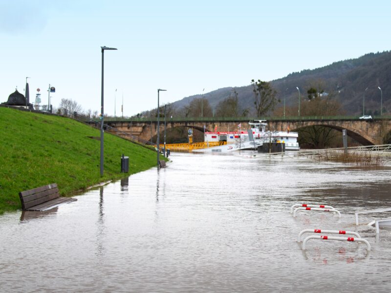
- In Spain, support will be added for flooding events and the wildfire use case will be enhanced.
- In Belgium, SAFEPLACE will introduce wildfire risk mapping in the Wallonia region and flood forecasting, and propagation information will be augmented.
Starion’s experts in Spain and Belgium are launching a new phase of enhancements to the SAFEPLACE crisis management platform to provide additional support for wildfire and flooding-related incidents. The integration of new real-time and predictive satellite-enabled data sources will extend the flood and fire services of SAFEPLACE, including the introduction of wildfire risk monitoring in Belgium’s Wallonia region and flood response support in Spain.
The SAFEPLACE platform is designed to support civil protection and emergency response organisations to make fast, informed decisions during crisis events such as wildfires, floods, toxic chemical spills and earthquakes by providing near real-time, actionable information. SAFEPLACE is being developed under the European Space Agency’s (ESA’s) Civil Security from Space (CSS) programme.
Platform-wide developments in this phase include provision of wildfire detection and early warnings for ignition causes other than lightning, which is already in place, to strengthen preparedness and response measures. The SAFEPLACE Crisis Assistant will be improved based on user feedback and extended to help operators respond to flooding events in addition to wildfires. The team will also be improving the capabilities for victim detection and 3D damage assessment in response to earthquake events; this will involve a study into the feasibility of incorporating neuromorphic processing of image data onboard drones. This innovative AI approach, which is inspired by the human brain’s structure that enables fast, very energy-efficient decision-making in highly constrained environments, will involve a collaboration between VITO and a new project partner, EDGX.
Country-specific enhancements
In Belgium, SAFEPLACE will benefit from additional flood monitoring support leveraging water level sensors and the integration of the FastFlood service to support flood forecasts and flood propagation models. The flood extent service from VITO will also be further improved using data from Sentinel-1 and -2 satellites. Also in Belgium, SPACEBEL will introduce wildfire risk mapping in Wallonia using multiple Earth observation and other datasets, while Constellr will provide land surface temperature imagery.
In Spain, which experienced severe flooding this winter and recorded its wettest January and February in almost half a century, Vodafone’s Network as a Sensor combined with satellite data will be used to provide flood risk mapping. This dynamic map will illustrate the potential flooded areas associated with simulated flood extents, while also enabling the generation of flood risk alerts through a modelling chain that links rainfall forecasts with hydrological and hydraulic models. For wildfire scenarios, enhancements will be implemented based on users’ feedback provided in the previous phase, together with the addition of new functionalities on wildfire detection and confirmation using thermal imagery from AISTECH as a new partner.
Silvia de Castro Garcia, Starion Managing Director, said: “This extension to the SAFEPLACE platform will bring valuable new capabilities to support crisis management and first responder organisations before, during and after a crisis. As our teams develop SAFEPLACE, we are prioritising the development of robust, scalable solutions that align with each country’s strategic goals and the operational needs of key stakeholders.”
The new capabilities being developed in this extension phase will be exhibited in two demonstrations. At the end of November 2026, wildfire and flooding additions to the chatbot will be presented, followed by a full demonstration of SAFEPLACE’s enhanced capabilities at ESA’s European Space Security and Education Centre (ESEC) in Belgium in January 2027.
The announcement of extensions to SAFEPLACE’s capabilities in Belgium and Spain follows a recent announcement of a project to define the priorities and requirements for a Luxembourg extension to the platform, focusing on flooding and humanitarian use cases.
Further information
The SAFEPLACE platform is structured around a centralised SAFEPLACE Hub with regional crisis nodes (RCNs) in each country where the service is being developed and delivered. The RCNs are secure national data clouds used for managing crisis data while the Hub enables seamless cross-border data and tool exchange, and enhances multi-national crisis response.
SAFEPLACE’s Hub–RCN design takes account of key national and European regulatory, commercial and technical constraints by offering configurable data governance, tiered access control and federated data exchange.